Kargil
Kargil District comprises the western parts of Ladakh region - the river valleys formed by the Himalayan tributaries of the Indus. Prominent among these are the Suru and Zanskar Valleys, which nestle along the northern flank of the Great Himalayan wall. The other prominent areas are the valleys of Drass, Wakha-Mulbek and Chiktan.
These valleys are believed to be originally colonized by the earliest settlers of Ladakh: the Indo-Aryan Mons from across the Himalayan range, assorted Dard immigrants from down the Indus and itinerant nomads from the Tibetan highlands. The region has a population of approximately 125,000 mainly agrarian inhabitants of which about 85 % are Muslims, mainly of the Shia sect, Islam having been introduced to the original Buddhist population around the middle of the 16th century by missionaries from Kashmir and Central Asia.
This region is mainly populated by the Purig-pa, meaning inhabitants of Purig area. Locally the area has always been identified as 'Purig’. Kargil was used to identify the whole region only after the Dogra rulers established their administrative centre and garrison headquarters in the present town of Kargil during the mid 19th century. The Purig-pa as an ethnic group are believed to have originated as a result of the intermixing of the earliest Dard colonizers with the Tibetan nomadic tribes in the process of settling down in the river valleys. Subsequently, as Baltistan established its suzerainty over the region from time to time, it received strong ethnic and cultural influences from the Baltis, a people of archaic Tibetan ancestry, due to which they are sometimes identified and wrongly described as Baltis.
Kargil Town - Kargil Town (2,704 m), situated midway between Srinagar (204 Kms) and Leh (234 kms) on the Srinagar-Leh highway, is the second largest urban centre of Ladakh and headquarters of Kargil district. It lies nestling along the Suru River and its tributary, the Wakha-chhu. In the past Kargil served as an important crossroads for the Central-Asian merchants due to its equidistant location (about 200-230 kms) from Srinagar, Leh and Skardo, all well known trading outposts on the old trade route network. Being located in the lap of the Himalayas, Kargil serves as an important base for adventure tourism and visiting the Zanskar Valley. Visitors travelling between Srinagar and Leh have to make a night halt here before starting the second leg of their journey. The town also offers several excursion options.
Sightseeing & Excursions
Mulbek - Situated 45 kms east of Kargil on the road to Leh, Mulbek (3,230 m) is a predominantly Buddhist area. Some monuments of the early Buddhist era dot the landscape among which the chief attraction is Mulbek Chamba, a 9-m high rock sculpture in deep relief of the Maitreya, the ‘Future Buddha’, which reflects a unique blend of esoteric Saivite symbolism, with early Buddhist art. Situated right on the highway, it dates back to the period when Buddhist missionaries came travelling east of the Himalayas during the 7th and 8th century.
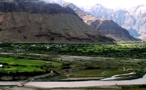
Drass - Drass (3,230 m), 60 km west of Kargil on the road to Srinagar is a small township in the centre of a valley of the same name. Locally called Hembabs, it is renowned as the second coldest inhabited place in the world. Winter temperatures here are known to plummet to 40 degrees Celsius below zero. During the spring and summer, the surrounding hillsides of the valley turn into green pastures splashed with a variety of wild flowers.
The population of Drass is mainly composed of Dards who are descendents of immigrants from Gilgit and other Dardic areas from down the Indus. They speak Shina, which belongs to the Indo-European linguistic family. A hardy people enduring with fortitude the harshness of the world’s second coldest place, the people of Drass are known to have negotiated the formidable Zoji-la pass, even during the late autumn or early spring for transporting traders’ merchandise and to help stranded travellers. They are also credited with having kept the Dak running throughout the year during the years before existence of the Kashmir-Ladakh road. By virtue of their mastery over the Zojila pass, they had established a monopoly on the carrying trade of the Central Asian trade.
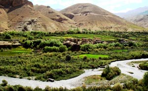
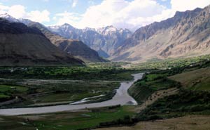
Suru Valley - One of the most beautiful and fertile regions of Ladakh, the Suru Valley is the heartland of Kargil district. Nestling along the northern foothills of the Great Himalayan Wall, it extends from Kargil town eastward for nearly 165 Kms, up to the foot of the Penzila watershed where the Suru River rises.
The upper reaches of the valley, particularly around Sankoo, Panikhar and the higher stretches beyond, have breathtaking features - majestic mountain ranges crowned by snow-capped peaks, alpine slopes drained by wild mountain streams, glaciers descending along the Himalayan slopes in impressive formations, quaint villages straggling dry hillocks surrounded by cultivated fields. The natural beauty of this area is enhanced by the towering peaks of Nun (7135 m) and Kun (7087 m) which the dominate the horizon.
The drive into the Suru Valley takes one through many picturesque villages such as Trespone, Saliskut area, Sankoo etc. Across Sankoo is the ancient village of Kartse-Khar, where a 7-m tall rock sculpture of the “Future Buddha”, provides evidence of the passage of Buddhist missionaries through the region during the 7th- 8th centuries AD.
Panikhar: This is the most picturesque expanse of Suru Valley overlooked by the Nun-Kun massif. Once an important intersection of trade and migration route, it is now the base station for mountaineering expeditions to the surrounding Himalayan peaks. Tangol, the approach base for climbing Mt. Nun, is just 6 kms ahead on the roads to Zanskar. A short walk up the hill slopes from here takes one across the Sentik ridge to the base camp on the rim of the ice plateau. Near Parkachik is the majestic Parkachik Glacier spilling down the Nun-Kun slopes, to collapse into the Suru River forming a big icefall. One can walk up to the glacier across a good suspension footbridge.
Rangdum - The farthest and most isolated part of the Suru valley, Rangdum (3657 m) is surrounded by colourful hills on the one side and glacier-encrusted mountains on the other. Situated 130 kms south-east of Kargil, it falls midway between Kargil and Padum. The main attraction of Rangdum is the 18th century Buddhist monastery of the Geluks-pa order with about 40 resident monks. Perched picturesquely atop a central hillock surrounded by a wild mountain stream, the monastery houses an array of figures and art objects. Two small hamlets, Yuldo and Tashi-Tongze, located on either end of the valley, are inhabited by the descendants of the monastery's agricultural serf-tenants.
Kargil - Factfile |